This Week in Weather — August 30, 2026
Severe weather rearview, storm reports, and the forecast pattern for the week of August 30, 2026.
Rearview
The week's headline number is 737 severe thunderstorm warnings — the single largest category in a 1,522-warning total that also included 153 flash flood warnings and 13 tornado warnings across the contiguous U.S.
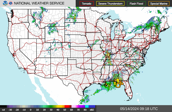
The tornado cluster on the evening of August 27 (EDT) is the sharpest story. Between 5:59 p.m. and 6:32 p.m. EDT, the Albany NWS office issued warnings for Ulster, Saratoga, and Washington counties in New York, followed minutes later by a warning from the Binghamton office for Delaware County. Lancaster County, Pennsylvania received its own warning just after 8:24 p.m. EDT on August 28. The Beaufort, South Carolina warning on August 29 arrived at 2:38 a.m. EDT — the lone overnight event in the sequence. The SPC logged 5 confirmed tornadoes for the week, a modest count relative to the 668 wind reports and 125 hail reports that dominated storm data. Top report totals by state: Texas at 92, Nebraska at 81, North Carolina at 60.
 NOAA/NWS
On August 25, the sun produced an M7.0 X-ray flare at 10:02 UTC — the strongest solar event of the week. Despite that classification, the planetary Kp index peaked at 0, meaning the flare did not drive a geomagnetic disturbance. No significant aurora activity resulted.
Seismically, a M6.0 struck 145 kilometers north of Caluula, Somalia on August 27 at 21:07 UTC — the week's largest earthquake. A M5.2 near Kodāri, Nepal and a M4.9 near Jalālābād, Afghanistan rounded out the notable seismic activity, both consistent with ongoing tectonic stress along the Himalayan convergence zone.
 USGS
USGS
The dust warning count — 7 DS.W and 21 DS.Y — reflects continued dryness across portions of the Southwest and southern High Plains.
Roadmap
The dominant feature through the coming week is a broad upper-level ridge anchored over the southern tier of the country, with its core sitting over Texas and the central Gulf Coast. Dallas is forecast to average 100°F for the week with essentially no precipitation — 0.01 inches total, peak probability of 12% on September 1. Atlanta is similar: 95°F average high, 0.02 inches of rain, peak probability of 24% on September 4. The ridge is suppressing convective initiation across both regions by maintaining strong subsidence and elevated dewpoints that can't overcome the capping inversion. This is not a pattern that breaks easily.
The more active story unfolds along the ridge's northern and western flanks, where shortwaves embedded in the westerly flow are providing lift.
Midwest. Chicago is looking at the week's most concentrated precipitation window: 1.17 inches total, with a 74% probability spike on August 30. That signal points to a well-organized shortwave passage rather than ordinary afternoon convection. Given the SPC's recent wind-report totals from Nebraska and the Dakotas, the favored convective mode ahead of any approaching trough will likely be linear and fast-moving. Damaging wind gusts are the primary concern; hail is secondary. The region had 153 flash flood warnings last week, and antecedent soil moisture from recent convection could make runoff a factor if training storms develop.
 M. Klüver / Wikimedia
Mountain West. Denver's 83% precipitation probability on August 31 is the highest regional peak in the dataset — and it arrives on a Wednesday, not a weekend. The mechanism is the North American Monsoon, which continues to pump Gulf of California moisture northward into the Four Corners and Front Range. Afternoon convection over the Palmer Divide and the I-25 corridor is the expected delivery system. At 90°F average highs, the instability is there; the question is whether outflow from one storm cluster can trigger the next. Flash flooding in burn scars across southern Colorado and northern New Mexico remains a secondary but credible risk through the period.
Northeast. New York City averages 82°F for the week with 2.08 inches of precipitation — the second-highest regional total — and a 59% peak probability on September 1. The pattern here is a series of disturbances rotating around the base of a trough positioned over eastern Canada. That trough is also what's keeping the Northeast from the ridge-dominated heat gripping the South. The August 27 tornado cluster across the Hudson Valley and Catskills demonstrated that this corridor can generate significant convection when Gulf moisture and a shortwave align; the September 1 window merits attention for similar reasons.
International callout. London's 72°F average high this week is unremarkable by late-August standards. The more notable context is what's happening to London's east: the same ridge influencing the U.S. pattern has an Atlantic analog that has been suppressing frontal passages into Western Europe through much of August. A 72°F week in London in early September is comfortable, but the persistence of that ridge is worth watching as the Atlantic storm track begins its seasonal southward shift into autumn.
The Takeaway
- The August 30 severe weather window for the Chicago metro is the highest-probability event of the coming week — wind damage is the primary threat, and the setup warrants watching evening timing for any squall line development.
- Denver's August 31 convective peak coincides with Labor Day weekend travel; afternoon departure windows from DIA and mountain corridors should be planned with storm initiation in mind, typically between 2 and 5 p.m. MDT.
- The southern Plains heat is not a transient spike — Dallas at 100°F average with no meaningful precipitation through the week means heat stress accumulates daily, and any outdoor work or activity should be front-loaded to morning hours.