
This Week in Weather
Rearview of the past 7 days and the pattern shaping the week ahead.
Rearview
The week's defining number is 28: tornado warnings issued across the central and southeastern U.S. between May 7 and May 9. That count came from two distinct geographic bursts separated by roughly 40 hours.
The first erupted across the Florida Panhandle on the afternoon of May 7. Starting at 10:03 a.m. CDT, the Tallahassee NWS office (TAE) issued four tornado warnings in rapid succession covering Holmes, Walton, Washington, Bay, Calhoun, and Jackson counties. A fifth followed at 12:18 p.m. CDT for Gadsden and Leon — counties that reach into the Tallahassee metro. Florida's panhandle is not immune to tornadoes in May, but a cluster of this density in a single morning is notable.
Wikimedia Commons
The second burst moved into southwestern Oklahoma late on May 8. The Norman office (OUN) issued a tornado warning at 6:42 p.m. CDT for Cotton and Tillman counties, followed by a second for Stephens County at 7:42 p.m. CDT on May 9. Oklahoma led all states for the week with 150 total storm reports — hail, wind, and tornadoes combined — which accounts for nearly a quarter of the national total of 512 SPC reports.
The full week's SPC log shows 31 confirmed tornadoes, 279 hail reports, and 202 wind reports. Mississippi (61 reports) and Texas (59) ranked behind Oklahoma, with Illinois and Alabama each clearing 30.
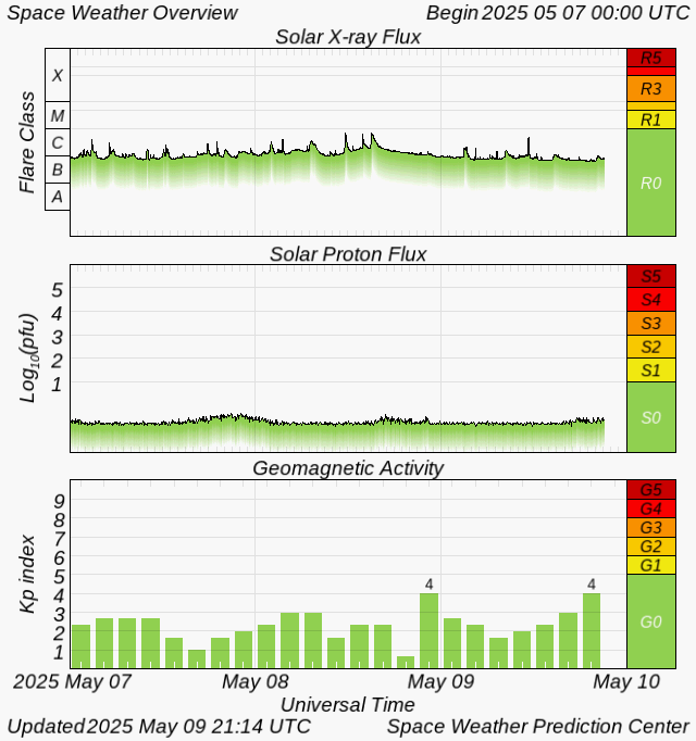
On the solar side, a quiet week by Kp standards — the index peaked at 0 — ended with a single M5.8 X-ray flare at 13:39 UTC on May 10. No geomagnetic disturbance accompanied it, but the flare class is worth tracking if the active region responsible remains geoeffective.
 NOAA SWPC
The week's largest seismic event, a M6.0 near Nena in the Philippines on May 4, produced no tsunami warnings.
Roadmap
The dominant pattern for the week of May 11–17 is a split-flow regime: a ridge anchored over the Desert Southwest and California coast, and a progressive trough swinging through the central and eastern U.S. That ridge is the reason Denver is looking at an 82°F average high and San Francisco sits near 67°F with only 0.02 inches of precipitation expected — both regions are effectively decoupled from the active weather to the east.
The trough's axis is the week's main organizing feature. As it digs into the Plains and lifts northeast, it will interact with Gulf moisture that has been cycling back into the South Plains since last week's convective rounds. Dallas is the most exposed major metro: an 86°F average high, 0.42 inches of precipitation expected, and a 41% peak precipitation probability on May 10 — already underway as this posts. The South Plains setup warrants attention through at least Tuesday; the same moisture feed that drove last week's Oklahoma and Texas reports has not dissipated, and the trough's passage will provide the lift to work with it.
 NOAA NESDIS
The Northeast sees the trough's downstream signature most clearly on May 13, when precipitation probability for the New York City area peaks at 81%. That's the sharpest probability spike in the national dataset this week — a number consistent with a coherent synoptic-scale system rather than isolated afternoon convection. Expect a wet Wednesday across the I-95 corridor, with the NYC area averaging a 70°F high for the week and accumulating roughly 0.21 inches total.
Chicago sits in the trough's wake: a 63°F average high, 0.30 inches of precipitation, and a modest 38% peak probability on May 12. That's a cooler, unsettled signal consistent with post-frontal flow rather than an active severe weather threat.
Atlanta is the week's quietest major market — 82°F average high, 0.00 inches of precipitation projected, and a 13% peak probability on May 11. The ridge edge keeps the Southeast largely suppressed.
Internationally, London's 57°F average high reflects a persistent Atlantic pattern keeping western Europe in cool, stable air while the U.S. trough drives the week's activity eastward. Nothing anomalous there, but the contrast is notable for anyone tracking transatlantic teleconnections.
The M5.8 flare on May 10 is worth a brief forward note: if the source active region rotates into a more geoeffective position over the next several days, another moderate flare could produce a minor geomagnetic disturbance by mid-week. Kp forecasts from SWPC should be checked by anyone with HF radio dependencies or aurora interest at higher latitudes.
The Takeaway
The South Plains remain the primary severe weather target through at least Monday, May 11 — anyone in the Dallas–Oklahoma City corridor should have a plan for Wednesday's potential convective window as the trough clears. The Northeast should treat Wednesday, May 13 as a travel disruption day, not just a rain day, given the 81% precipitation probability and the organized synoptic forcing behind it. Monitor SWPC's Kp forecasts through mid-week; the May 10 M5.8 flare was not geoeffective, but the active region's position relative to Earth changes daily.