This Week in Weather — July 5, 2026: Wind Event & X1.3 Flare
2,576 wind reports, July 4–5 tornado warnings, an X1.3 solar flare, and the southern heat ridge for the week ahead.
Rearview
The week's defining number is 2,576 — SPC wind reports across the lower 48 in seven days, a figure that dwarfs the 401 hail reports and 29 confirmed tornadoes and reflects a pattern dominated by fast-moving linear convection rather than discrete supercells.
The most geographically concentrated severe weather arrived on July 4th and 5th. On the afternoon of July 4 (CDT), tornado warnings fired in quick succession across central Illinois — Ford and Livingston counties from the Chicago office — and simultaneously in Stearns County, Minnesota. Less than 24 hours later, the threat had shifted east: three separate tornado warnings covered Mahoning and Portage counties in northeastern Ohio on the afternoon of July 5 (EDT), issued by the Cleveland office within roughly 50 minutes of each other. That same evening, a warning reached St. John the Baptist Parish in Louisiana — late afternoon CDT, a geography that rarely sees tornado warnings outside of tropical events.
Pennsylvania and New York led all states in total SPC storm reports at 289 and 245 respectively, consistent with a mid-Atlantic wind event that outpaced the Plains in raw report counts. South Dakota's 207 reports point to a separate, hail-productive round across the northern High Plains, where discrete supercell mode was more likely given the drier boundary layer.
On the geophysical side, a M6.2 struck 58 km west of Tobelo, Indonesia on July 3 — the largest seismic event of the week globally. Domestically, a M3.8 near Oak Harbor, Washington registered on July 3, notable for its proximity to a populated Puget Sound community.
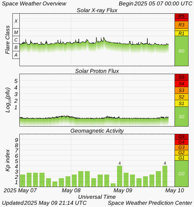
Space weather was quiet by Kp index (maximum of 0 for the week), but the sun produced an X1.3 flare at 20:41 UTC on July 4 — strong enough to cause high-frequency radio blackouts on the sunlit side of Earth at the time of the event, though no significant geomagnetic impact followed.
 NOAA SWPC
Roadmap
The week of July 7–13 is shaped by a stubborn upper-level ridge anchored over the southern tier, with its axis running roughly from the Desert Southwest through Texas and into the Gulf Coast. That configuration does two things simultaneously: it parks dangerous heat across the South Plains and Southeast while funneling disturbances around the ridge's northern periphery, keeping the Northeast and parts of the Midwest in an active pattern.
 NOAA/NWS Weather Prediction Center
Northeast. The most dynamic week in the CONUS outlook belongs to the New York City corridor. A 76% precipitation probability on July 7 — the highest single-day figure in the entire dataset — points to a well-organized forcing event, likely a frontal passage or shortwave trough dropping out of Canada along the ridge's northern edge. With an average high of 82°F and 1.76 inches of projected weekly precipitation, this is not a scattered-afternoon-storm signal; the July 7 spike is sharp enough to suggest a defined lifting mechanism. Residents and event planners in the I-95 corridor from Philadelphia to Boston should treat Monday as the primary risk day.
South Plains and Southeast. Dallas averages 102°F for the week with only 0.20 inches of precipitation possible — nearly all of that front-loaded on July 5 (18% probability), after which the ridge reasserts and desiccates the pattern. Atlanta sits at 94°F average with 0.09 inches across seven days. These are not heat-advisory thresholds in isolation, but consecutive days at or above 100°F in Dallas with overnight lows that won't drop far enough for meaningful recovery represent cumulative physiological stress, particularly for outdoor workers. Denver's average high of 98°F with a 56% precipitation probability on July 8 reflects the classic monsoon-adjacent pattern: intense daytime heating, afternoon convective development, brief but locally heavy rain, then rapid clearing. The 0.04 inches of weekly total precipitation suggests most of that convection stays isolated.
Midwest. Chicago's 77°F average high and 51% precipitation probability on July 9 put the metro in a secondary active window, likely tied to the same disturbance train that moves through the Northeast earlier in the week. The 0.45 inches of weekly precipitation is modest but concentrated — worth watching for a brief severe weather window mid-week as the trough axis crosses the Great Lakes.
International. London's average high of 89°F for the week is the callout here. That figure sits roughly 14–16°F above the long-term July mean for the city, consistent with a southerly continental flow pattern that has periodically dominated western Europe this summer. The UK's housing stock — built for a climate that historically required heating, not cooling — has minimal air conditioning penetration, making heat events at this magnitude a genuine public health concern rather than a statistical anomaly.
 NOAA NESDIS / STAR
The Pacific Coast is effectively a non-event: San Francisco averages 68°F with zero precipitation probability for the week, locked under the persistent marine layer that defines early July on the Northern California coast.
The Takeaway
- The Northeast's primary weather risk this week is concentrated on July 7; if you have outdoor commitments in the New York-to-Boston corridor, that is the day to monitor, not the back half of the week.
- Dallas and Atlanta will accumulate heat stress across multiple consecutive days with negligible precipitation relief — the risk is duration, not a single extreme event.
- The X1.3 solar flare on July 4 produced no geomagnetic follow-through, but the active region that generated it may still be geoeffective; SWPC's 3-day forecast is worth a check if you operate HF radio systems or manage infrastructure sensitive to geomagnetically induced currents.