This Week in Weather — July 12, 2026
Severe weather rearview, storm reports, and the forecast pattern for the week of July 12, 2026.
Rearview
The week's most telling single number: 1,458 wind reports to 108 hail reports. That ratio points toward linear convective modes — squall lines and derechos — rather than the discrete supercells that tend to produce hail-heavy outbreaks.
 NWS Northern Indiana (IWX) storm survey / NOAA
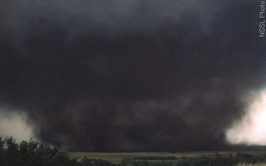
The severe weather pattern split into two distinct geographic stories. The Carolinas led all states with 247 storm reports, followed by South Carolina at 197. That concentration reflects a focused convective corridor along the Southeast's Atlantic slope. On the evening of July 10 local time, NWS Greenville-Spartanburg issued tornado warnings for Burke, Catawba, Cleveland, and Lincoln counties in North Carolina simultaneously — a tight geographic cluster suggesting an organized, fast-moving threat rather than isolated cells.
The Plains and Midwest contributed their share. On the evening of July 9 CDT, tornado warnings fired across Burleigh, Kidder, Sheridan, and Wells counties in North Dakota out of the Bismarck office, followed within the same overnight window by warnings in Benton County, Missouri (Springfield office) and Trigg County, Kentucky (Paducah office). Missouri finished the week with 108 storm reports, third nationally.
Iowa added a tornado warning for Cerro Gordo County on the afternoon of July 10 CDT, and Indiana closed the week's tornado warning sequence with Posey County on the evening of July 11 local time — the system's eastward progression visible in the warning geography alone.
 NOAA NSSL archive
Space weather was quiet. The week's most significant solar event was an M4.0 flare at 14:19 UTC on July 7, which did not produce geomagnetic activity of note; the maximum Kp index for the seven-day period was 0. Seismically, a M6.4 struck the South Sandwich Islands region at 10:26 UTC on July 11 — remote and tsunamigenic potential was assessed as low. Closer to population, a M4.1 occurred 2 km east-southeast of Frazier Park, California, a location in the Transverse Ranges that sits near the San Andreas fault system.
Roadmap
The dominant synoptic feature for the coming week is a broad upper-level ridge anchored over the western United States, with its axis positioned to keep Denver averaging 97°F and San Francisco a stable 72°F — the Pacific coast sitting under the ridge's western flank where subsidence suppresses marine layer development and precipitation probability stays at or below 6% all week.
 NOAA
NOAA
The ridge's eastern edge is where the action concentrates. Gulf of Mexico moisture will remain available to the south-central and southeastern states, and the pattern favors episodic convective development rather than a sustained frontal passage.
Southeast: Atlanta averages 90°F through the week with 0.44 inches of total precipitation — modest in volume but concentrated. The peak precipitation probability of 68% on July 14 stands out as the sharpest signal in the national outlook. A 68% probability on a single day, against a weekly total that low, suggests a defined forcing mechanism moving through — likely a shortwave impulse riding the ridge's eastern periphery — rather than random afternoon convection spread across multiple days. This is the window to watch for organized convective development from northern Georgia into the Carolinas, a region that just demonstrated its capacity for severe weather this past week.
South Plains: Dallas averages 93°F with a 43% precipitation probability on July 13, one day ahead of the Southeast's peak. The sequencing is consistent with a disturbance tracking northeast — reaching the Dallas area on the 13th and the Atlanta corridor on the 14th. Total weekly precipitation for Dallas is projected at 0.25 inches, so the event, if it verifies, will likely be convective and localized rather than widespread.
Northeast and Midwest: Both regions sit on the dry side of any meaningful moisture transport. New York City averages 91°F with zero projected precipitation and only a 27% probability on July 18 — the tail end of the week. Chicago comes in at 86°F with 0.04 inches total. The ridge suppresses storm development, but the heat itself is the story: sustained highs in the upper 80s to low 90s across the urban Northeast, with overnight lows that will remain elevated enough to prevent meaningful recovery. This is a heat accumulation pattern, not a severe weather pattern.
International callout: London's average high of 83°F over the coming week is anomalous for mid-July. Northwestern Europe has been operating under a persistent anticyclonic pattern, and 83°F in London — a city whose infrastructure and building stock were not engineered for sustained summer heat — carries health implications that temperature alone doesn't fully convey. The European heat health warning systems will likely be active.
What to Watch
- The July 14 convective window for the Southeast is the highest-probability discrete event in the national outlook; interests from northern Georgia through the western Carolinas should monitor NWS mesoscale discussions beginning July 13 for timing and mode.
- The South Plains shortwave on July 13 is the upstream trigger for that Southeast sequence — if it underperforms or tracks differently, the July 14 Atlanta-area signal degrades accordingly.
- Denver's projected 97°F average high with near-zero precipitation probability means the Front Range urban corridor will be under sustained heat stress; ozone conditions and wildfire risk in adjacent foothills terrain both warrant daily monitoring through at least July 18.