This Week in Weather — July 26, 2026
Severe weather rearview, storm reports, and the forecast pattern for the week of July 26, 2026.
Rearview
The week's most concentrated severe weather moment arrived in northern Minnesota late Thursday evening local time: six tornado warnings dropped across Marshall, Pennington, Polk, Red Lake, Beltrami, Clearwater, Itasca, and Koochiching counties between 6:20 p.m. and 8:07 p.m. CDT on July 24–25, issued from both the Grand Forks (FGF) and Duluth (DLH) offices. That is a geographically broad corridor for a single evening's tornado warning sequence — spanning from the Red River valley northeast into the Arrowhead region.
The broader week logged 53 tornado reports, 75 hail reports, and 861 wind reports across the SPC database. The wind-to-hail ratio is notable: a 11-to-1 skew toward wind suggests the dominant convective mode was linear and fast-moving rather than discrete supercell activity. South Dakota led all states with 102 combined storm reports.
 NOAA NESDIS
The Appalachian tier also took a significant hit. Kentucky (88 reports), West Virginia (85), Ohio (78), and Virginia (76) collectively account for more than 40 percent of the week's storm reports — a region where complex terrain tends to amplify wind damage from organized convective lines and where flash flooding risk compounds quickly.
On the space weather side, an M3.5 solar flare peaked at 06:34 UTC on July 22. Maximum Kp for the week reached zero, meaning no geomagnetic disturbance followed. The flare was a single-event spike, not part of a sustained active period.
The week's largest seismic event was a M6.0 strike 82 km west of Sola, Vanuatu on July 24 — routine for the Vanuatu arc, which sits atop the convergence zone between the Australian and Pacific plates. Domestically, a M5.0 occurred 38 km south-southeast of Spearman, Texas, in the Oklahoma Panhandle seismic zone, which has seen elevated activity in recent years tied to wastewater injection operations.
Roadmap
 NOAA CPC
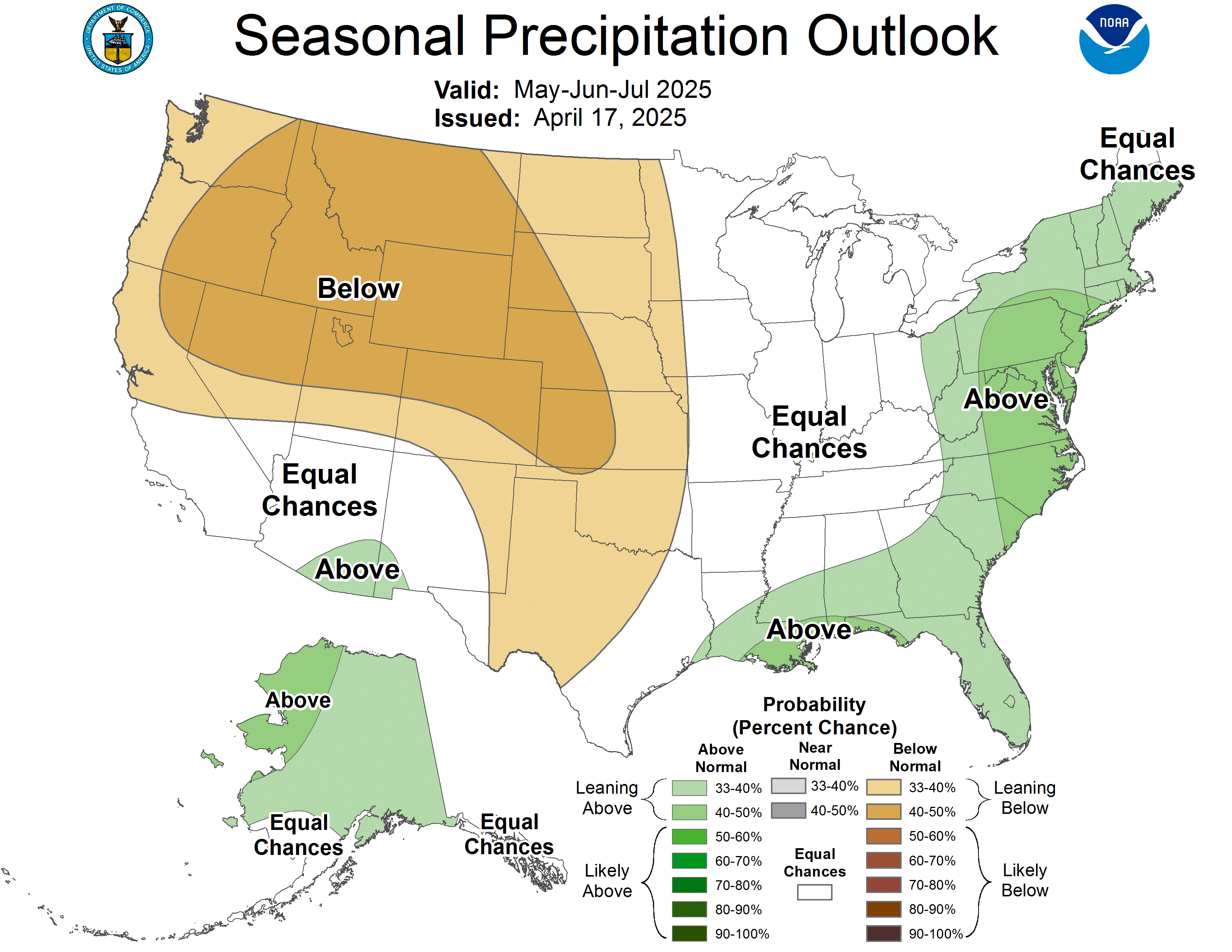
The dominant feature shaping the next seven days over the contiguous U.S. is a sprawling upper-level ridge anchored over the southern Plains and Gulf Coast states. At its core, the pattern is a textbook mid-summer heat dome configuration: a positively tilted 500-hPa ridge suppresses convective initiation across the south-central tier while simultaneously funneling the jet stream well into Canada. The southern branch of the westerlies is effectively absent below roughly 45°N through at least mid-week.
That ridge position creates two distinct weather regimes: a suppressed, hot interior south where afternoon surface temperatures will consistently run 5–8°F above climatological norms, and an active northern periphery where the jet stream's residual energy can tap Gulf moisture that manages to advect northward along the ridge's eastern flank.
Northern tier and Great Plains
The active zone from last week's Minnesota tornado sequence is not going away. The same ridge-periphery dynamics that fueled Thursday evening's northern Minnesota outbreak will remain in place through at least Tuesday. Shortwave energy rotating around the top of the ridge will provide periodic lift across the Dakotas, Minnesota, and Wisconsin. Afternoon and early evening convective initiation is the primary timing window — surface heating destabilizes a relatively moist boundary layer, and any organized linear system that forms has a clear path eastward into the western Great Lakes. Severe wind and hail are the primary hazards; tornado potential is lower than last week but not zero, particularly on days when a surface boundary lingers from overnight convection.
 Greg Lundeen / NOAA
Southern tier
Texas, Oklahoma, Arkansas, and the Lower Mississippi Valley are under the ridge core. Little to no precipitation is expected through the weekend. High temperatures in Dallas and Oklahoma City will approach or exceed 105°F on multiple days. The relevant hazard here is not convective — it is cumulative heat load. Overnight lows in the upper 70s to low 80s across urban Texas metros mean heat stress does not reset between days, and that compounding effect becomes medically significant by day three or four of a sustained run.
Eastern U.S.
A shortwave trough is expected to dig into the Ohio Valley mid-week, providing the most significant severe weather opportunity east of the Mississippi since last week's Appalachian wind event. The setup favors a corridor from the mid-Ohio Valley through the central Appalachians and potentially the mid-Atlantic on Wednesday into Thursday. Given the terrain and antecedent soil moisture from last week's activity, flash flooding will be a co-equal concern alongside wind and hail. The SPC's day-4 and day-5 outlooks will be the key products to watch starting Monday.
International callout — Western Europe
A persistent upper-level low off the Iberian Peninsula has been directing a succession of Atlantic disturbances into France, Germany, and the Low Countries. This is the inverse of the North American pattern: where the U.S. ridge is suppressing precipitation, Europe's anomalous trough position is producing repeated rounds of heavy convective rainfall across a region that saw significant flooding in late June. Flash flood watches have been active across parts of southern Germany and Austria. The pattern is not expected to break before the end of the month.
Field Notes
- If you are in the northern Plains or upper Midwest, treat Tuesday afternoon as the next significant convective window and have your severe weather plan current before noon local time.
- The mid-week shortwave is the week's most consequential forecast uncertainty — its exact track will determine whether the Ohio Valley or the mid-Atlantic takes the primary severe weather hit, and that distinction matters enough to re-check NWS area forecasts on Monday and Tuesday rather than anchoring to today's model guidance.
- The M5.0 near Spearman, Texas warrants a note if you have infrastructure or family in the Oklahoma Panhandle region: the induced seismicity zone there has produced sequences of follow-on events in past years, and USGS ShakeAlert feeds are worth monitoring through mid-week.