This Week in Weather — September 6, 2026
Severe weather rearview, storm reports, and the forecast pattern for the week of September 6, 2026.
Rearview
The week's defining number is 1,740 — wind reports logged to the Storm Prediction Center between August 30 and September 5, a figure that dwarfs the 130 hail reports and 15 confirmed tornadoes and tells you something about the dominant convective mode: fast, linear, surface-driven.
The heaviest concentration of that damage fell across the Mid-Atlantic and Appalachians. On the afternoon of September 3 (EDT), the State College, Pennsylvania office issued back-to-back tornado warnings for Bedford, Cambria, and Somerset counties within 15 minutes of each other — a cluster that contributed to Pennsylvania finishing the week as the top storm-report state at 288 total. Virginia and North Carolina followed at 200 and 217, respectively, indicating the convective axis stayed well east of its climatological center through much of the week.
 NOAA/NWS Weather Prediction Center
The Mid-Atlantic activity continued into September 4. That evening, the Wakefield, Virginia office issued a tornado warning covering Isle of Wight, Southampton, and the City of Franklin simultaneously — three jurisdictions in a single polygon, suggesting a well-organized circulation moving through a densely populated rural corridor. Hours later, in Wisconsin, the La Crosse office issued a warning for Clark County just before midnight local time, an overnight event that would have caught many residents already asleep.
Farther north, a September 4 overnight warning from the Grand Forks office covered Grant and Otter Tail counties in Minnesota — not a region that sees frequent tornado warnings in September, and a reminder that the severe weather season doesn't end at the Labor Day calendar marker.
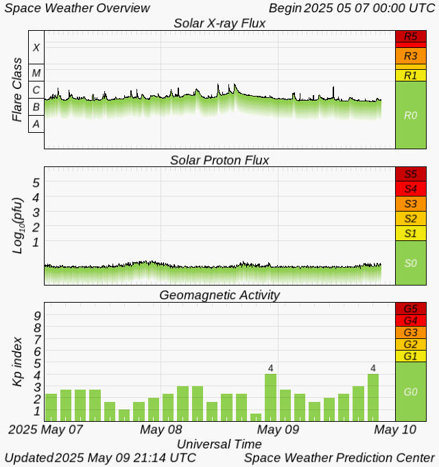
The geophysical week produced a M6.3 earthquake 84 km SSW of Nikolski, Alaska on September 3 — large enough to trigger tsunami evaluation protocols, though no destructive wave followed. Solar activity remained quiet, with a maximum Kp of 0, though an M3.0 flare on September 2 briefly elevated X-ray flux.
 NASA DTAM project team
 NOAA SWPC
Composite radar, 2026-09-03 to 09-04. The convective line maintained organization from the Appalachian front range through the Tidewater.
Roadmap
The pattern shaping the week of September 7–13 is a heat-dominated south and a moisture-starved northeast, with the Midwest carrying most of the week's convective load. A persistent upper-level ridge centered over Texas is the controlling feature — it's keeping Dallas at an average high of 100°F through the period and suppressing precipitation probability to just 11% even at peak (September 10). That ridge is not static, however. A shortwave trough digging into the northern Plains mid-week is the primary disturbance to watch, and its track will determine how much severe weather potential materializes east of the Mississippi.
Midwest. Chicago's week peaks at 80°F average high, which sounds benign, but the precipitation probability reaches 69% on September 9 — the highest single-day figure in any region this week. That signal is consistent with the shortwave passage, and given the week's established pattern of linear convection, the convective mode is likely to favor squall lines over discrete supercells. Total weekly precipitation for the Chicago area is projected at 0.41 inches, nearly all of it concentrated around that Tuesday window.
Southeast. Atlanta averages 91°F through the period, with the peak precipitation probability — 51% — arriving on September 11, a day after the Midwest event. That timing is consistent with the shortwave's eastward progression and the attendant surface low tracking across the Tennessee Valley. The week's total precip for Atlanta is 0.26 inches, modest but not negligible given the heat load. Afternoon convection building off elevated terrain to the north is the most likely delivery mechanism.
500 mb forecast, 2026-09-09. The shortwave's amplitude and track will be the key variable for Midwest and Southeast severe weather timing.
Northeast. The region sits in the ridge's eastern periphery. New York City averages 82°F — warm but not exceptional for early September — and the week's total precipitation is just 0.02 inches. The peak probability of 31% on September 10 likely reflects the trailing edge of the same shortwave that hits the Midwest a day earlier, but the moisture supply is thin enough that widespread convection seems unlikely. Isolated afternoon showers are the more probable outcome.
Pacific Coast and Mountain West. San Francisco sees zero precipitation probability of note through the period, with a 6% peak on September 9 that is within the noise floor of the model. Denver averages 90°F — elevated for mid-September — with 0.41 inches of weekly precip driven by the region's diurnal convective cycle. The Mountain West total matches Chicago's, but the mechanism is entirely different: terrain-forced afternoon convection rather than synoptic forcing. September 12 carries the highest Denver-area probability at 27%.
International. London averages 70°F through the week, which is seasonally appropriate and suggests the Azores-rooted ridge that has been suppressing Atlantic frontal passages is relaxing slightly. No significant pattern disruption expected for western Europe this week.
What to Watch
- The September 9 Midwest convective window is the week's clearest severe weather opportunity — anyone with outdoor events in Illinois, Indiana, or southern Wisconsin should have a decision framework in place by Saturday morning.
- The M6.3 near Nikolski, Alaska remains worth monitoring for aftershock activity; the Aleutian arc is seismically active and a follow-on event above M5.5 in the next 7–10 days would not be anomalous.
- Dallas-area heat peaking near or above 100°F through the week warrants attention for heat-related illness, particularly for outdoor workers — the low precipitation probability means no evaporative relief is likely before September 12.