This Week in Weather — September 20, 2026
Severe weather rearview, storm reports, and the forecast pattern for the week of September 20, 2026.
Rearview
The week's most geographically improbable entry: a tornado warning issued at 1:44 p.m. MDT on September 18 covering Davis, Morgan, and Weber counties in Utah — a state that averages roughly two confirmed tornadoes per year. The Salt Lake City forecast office (SLC) issued the warning; whether it verified is unconfirmed in the dataset, but the atmospheric setup that produced it is worth noting on its own terms.
The Great Plains delivered more expected violence. Two overlapping tornado warnings out of the Omaha office (OAX) on the evening of September 14 — the first at 6:40 p.m. CDT, the second at 6:55 p.m. — covered Fremont and Cass counties in Iowa and Nebraska's Otoe County. The week's final tornado warning came Saturday, September 19, when the Goodland, Kansas office (GLD) flagged Cheyenne County, Colorado and Wallace County, Kansas at 6:36 p.m. MDT.
Kansas led all states in SPC storm reports with 95, followed by North Carolina (40), Missouri (34), Ohio (33), and Nebraska (32). The week's total: 7 tornadoes, 87 hail reports, 420 wind reports — 531 severe thunderstorm warnings in all, against only 5 tornado warnings, a ratio that reflects the week's dominant convective character: wind-driven and widespread rather than discrete and rotating.
Flash flooding drew significant attention in western Pennsylvania. A flash flood warning from the Pittsburgh office (PBZ) covered Washington County at 10:37 a.m. EDT on September 20, one of 253 FF.W events nationally. The week's 415 flood advisories and 46 flood warnings reinforce that saturated soils and slow-moving convection were as consequential as severe wind this period.
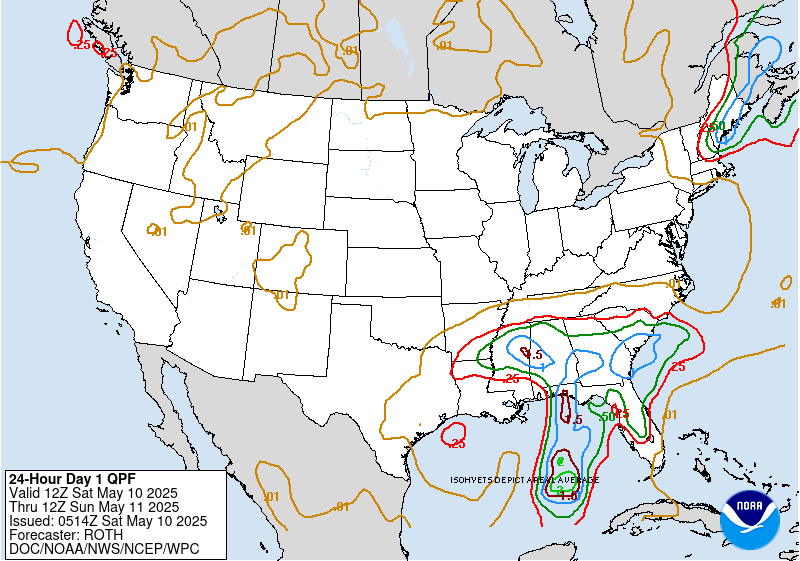 NOAA/NWS Weather Prediction Center
Seismically, a M6.5 struck 169 km west of Nikolski, Alaska on September 17 at 14:19 UTC — flagged with a tsunami assessment. A M6.4 followed near Kainantu, Papua New Guinea. Neither generated a destructive tsunami, but the Aleutian event was the week's largest recorded ground motion globally.
 USGS
USGS
Roadmap
The pattern entering the new week is organized around a persistent ridge over the southern tier and a more active, amplified flow across the northern half of the country. A shortwave trough tracking out of the Rockies is the primary forcing mechanism for the early-week severe weather window, particularly across the Midwest. Behind it, a reinforcing cold push drops mean heights across the Great Lakes and Northeast, keeping temperatures well below the seasonal norm for late September in those regions.
The South Plains sits under the ridge's direct influence. Dallas is looking at an average high of 96°F through the week — that's 10 to 12 degrees above the late-September climatological average for the region — with almost no precipitation signal: 0.07 inches total, peak probability just 18% on September 21. The ridge is not breaking. Anyone managing outdoor work in north-central Texas or southern Oklahoma should treat this as a multi-day heat event, not a temporary spike.
Midwest and Ohio Valley. Chicago's 100% precipitation probability on September 20 is the most confident signal in the dataset. That confidence reflects a well-defined synoptic setup: the shortwave trough, surface low development, and sufficient low-level moisture to support widespread rainfall and likely a renewed severe weather window across the lower Great Lakes. Average high of 64°F for the week tells the temperature story — this is a cool, active pattern for the region, not a late-summer holdout. Anyone from Chicago east through Indiana and Ohio should expect September 20 to be a rain day with the possibility of embedded convection; the Ohio Valley severe reports from the past week suggest the atmosphere in that corridor remains primed.
Northeast. New York City averages 65°F for the week, with 1.71 inches of total precipitation and a peak probability of 69% on September 20 — timing that aligns with the same shortwave affecting the Midwest. The moisture plume likely arrives in the afternoon or evening EDT on Sunday, with lingering unsettled conditions possible into Monday. Flash flood potential is worth monitoring given the week's antecedent rainfall; Washington County, Pennsylvania's flash flood warning on September 20 is a preview of what saturated soils can do when even moderate rainfall rates stack on top of them.
Conceptual illustration of polar and subtropical jet streams.
 NOAA
NOAA
Mountain West and Pacific. Denver averages 79°F with just 0.12 inches of precipitation — the classic post-monsoon transition window where afternoon convection becomes increasingly isolated and the dominant story shifts to cooling nights. San Francisco's zero precipitation forecast and a 4% peak probability confirm the eastern Pacific ridge is still in control. The California coast is dry through at least September 27.
International. London's average high of 70°F is notable for late September — roughly 4 to 6 degrees above the long-term mean for the period. The same blocking pattern suppressing frontal activity across the North Atlantic appears to be keeping the U.K. in an anomalously warm, settled regime. Whether that holds into October depends on how quickly the Atlantic jet reasserts itself, but for now, London is running warmer than Chicago.
Field Notes
- If you're in the Chicago-to-Cleveland corridor, September 20 is a day to move outdoor plans indoors — the 100% precipitation signal in the Chicago forecast is the highest-confidence event in next week's data, and the severe weather history in Ohio this past week means convective potential can't be dismissed.
- The Aleutian M6.5 on September 17 had a tsunami flag attached; USGS and PTWC should be your first check for any Aleutian or Kamchatka event above M6.5, as the geometry of that arc focuses energy toward Hawaii and the U.S. West Coast.
- Dallas's 96°F average high through late September, with essentially no precipitation relief, means heat-related illness risk is real and compounding — acclimatization built up over summer doesn't eliminate risk when the calendar says autumn but the thermometer doesn't.