This Week in Weather — June 7, 2026: Alabama Leads Storm Reports
Alabama-led severe week, multi-state tornado sequence, M9.7 solar flare, and the Rockies ridge shaping the forecast.
Rearview
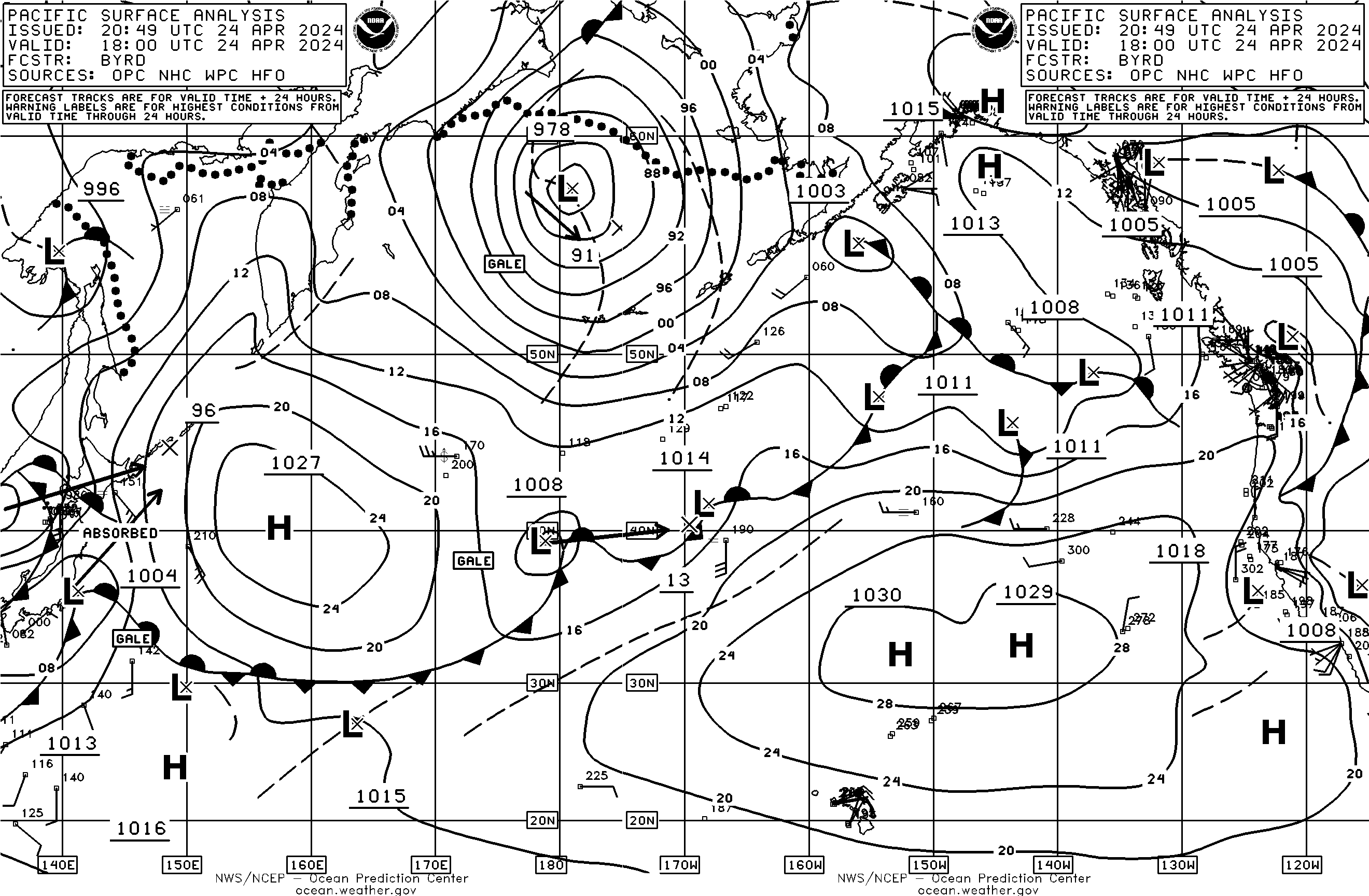
NOAA OPC
Alabama led the national storm report count for the week with 317 total reports — more than Pennsylvania (163), Missouri (114), and South Dakota (111) combined. That single-state concentration is the clearest signal of where severe weather's center of gravity sat during the first week of June 2026.
The week's most active convective day was June 7. The overnight hours into that morning brought the first tornado warnings: Bossier and Webster parishes in Louisiana received two TO.W issuances from the Shreveport office — at 9:14 p.m. and 10:10 p.m. CDT on June 6 — followed shortly after by a warning for Franklin County, Arkansas, issued at 9:08 p.m. CDT. Those three warnings in a roughly 62-minute window from two separate offices marked the opening of what became a multi-state tornado sequence.
By afternoon CDT on June 7, the convective focus had shifted northeast. Bureau County, Illinois, received a tornado warning from the Davenport office at 11:54 a.m. CDT. The Dade County, Missouri, warning from Springfield followed at 2:09 p.m. CDT. Johnson and Newton counties in Arkansas were warned by the Little Rock office at 2:46 p.m. CDT. Sixteen confirmed tornadoes appear in the SPC storm reports for the week, with 1,207 wind reports and 276 hail reports rounding out the severe weather picture.
The seismic week had two entries worth noting: a M6.2 struck 22 km WSW of Scarcelli, Italy, on June 1 at 11:12 p.m. local time, and a M6.0 hit 33 km NW of Valparaíso, Chile. Domestically, a M3.8 registered 11 km NW of Summerlin South, Nevada — shallow enough to be felt across the Las Vegas Valley.
On the solar side, an M9.7 flare peaked on June 3 at 11:27 UTC. It stopped just short of X-class, but produced no significant geomagnetic response — the Kp index maxed at 0 for the week.
Roadmap
 NASA
NASA
The dominant feature shaping the next seven days is a broad upper-level ridge anchored over the southern and central Rockies, with its axis running roughly from Denver through the Texas Panhandle. That ridge is responsible for the heat building across the South Plains — Dallas is looking at an average high of 94°F through the week — while also suppressing precipitation potential across Denver (0.00" projected, peak probability just 20% on June 13) and San Francisco (likewise 0.00", with a modest 21% chance on June 9 that likely reflects marine stratus rather than any meaningful precipitation).
The more interesting dynamics are on the ridge's eastern flank, where shortwave energy rotating around the base of a trough over the Great Lakes and Ohio Valley will keep the Midwest unsettled. Chicago's outlook carries 1.46" of projected precipitation for the week, with the highest probability — 56% — on June 9. That signal is consistent with a progressive frontal system tracking across the northern Plains and Great Lakes, likely organizing convection ahead of it as it sweeps east. The timing puts the highest overnight convective risk over the Midwest on Sunday night into Monday morning.
South Plains. Dallas is the week's most interesting regional story. The 86% precipitation probability on June 7 — which, given the forecast issuance date, represents the near-term edge of the outlook — is a sharp spike, suggesting a well-defined forcing mechanism rather than scattered afternoon convection. The ridge axis keeps most of the week dry, but the eastern edge of that ridge is where Gulf moisture can surge northward when the pattern briefly allows it. Any convection that fires in this environment, with surface temperatures near 94°F, will have substantial instability to work with.
Midwest and Southeast. Atlanta's 66% precipitation probability on June 9 and Chicago's 56% on the same date point to a coherent synoptic system moving through both regions in roughly the same 24-hour window — the Southeast catching the southern end of a frontal boundary, the Midwest taking the northern. Atlanta's weekly precipitation total (0.55") is modest, which argues against a prolonged heavy rain event and more toward a quick-moving frontal passage. Chicago's 1.46" is more substantial and spread across a wetter overall pattern.
Northeast. New York City sits in the quietest sector of the week. An average high of 82°F and only 0.32" projected precipitation through the period — with peak probability just 30% on June 10 — puts the region in a post-frontal, high-pressure-dominated regime for most of the week. The June 10 signal is likely the trailing edge of whatever system clears the Midwest on June 9.
International. London's average high of 65°F for the week is close to climatological normal for early June, which itself is a notable data point — the persistent blocking that pushed temperatures above seasonal norms across parts of northwestern Europe in recent weeks appears to have relaxed. No dramatic heat signal is present in this week's outlook.
 NOAA
NOAA
On the Radar
- If you are in the Dallas–Fort Worth corridor, the June 7 probability spike warrants checking local NWS forecasts before any outdoor evening plans — the combination of 94°F surface temperatures and Gulf moisture influx creates a high-instability environment if forcing materializes.
- The June 9 dual-region signal (Atlanta 66%, Chicago 56%) is worth monitoring for severe potential, particularly if the approaching system's timing shifts earlier and allows daytime heating to prime instability ahead of the frontal boundary.
- The M9.7 solar flare on June 3 produced no geomagnetic impact this time, but the active region responsible may still be on the solar disk — HF radio operators on trans-polar routes should continue checking SWPC advisories through mid-June.